Get away from it all in the Great Smoky Blue Ridge Mountains!
|
Recommended Area Links:
Surrounded by Six National Forests
Minutes from the Blue Ridge Parkway
White Water Rafting
Skiing, Fishing, Hiking, Sightseeing
Enjoy the Mountains of North Carolina
Relax and stay in our cabin, recharge...let the Appalachian's sink in
|
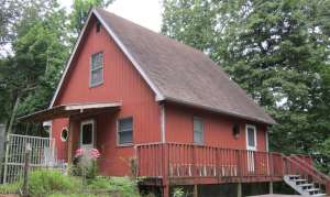
Line Runner Ridge Cabin
Tuck your family into the Two Bedroom Cabin. Sip a drink on the deck and watch the sun set before dinner and settle down with the glow of the wood stove...
Relax, you are in the mountains now....
|
Dismal Falls
Dismal Falls- Is On The West Fork of French Broad River. Left of State Road 1308 near Jackson County line in Pisgah National Forest, locally known as Owens Gap Road. Obtain directions at Lake Toxaway.
A creek named "Dismal" is the focus of a recreation area in the national forest west of the New River in southwestern Giles County. Dismal Creek drains a basin in the southeastern slope of Flat Top Mountain, the south slope of Sugar Run Mountain, and the northwestern slope of Brushy Mountain. Before leaving Giles County, the creek tumbles over Dismal Falls, a 10-foot drop over several levels of sandstone. The erosion-resistant rock is part of a formation over 400 million years old. The creek then heads for Bland County, adding its waters to cold Kimberling Creek, fresh out of Kimberling Creek Wilderness [Fig. 18(5)] to the west. The creeks are part of the Walker Creek and New River watershed.
By itself, the waterfall would draw visitors from the heat of pavement and treeless avenues. The falls are easily accessible by car, and the cool mountain air that flows down the gorge is a welcome balm to folks from nearby Bland and Pearisburg, and to travelers on Interstate 77 with an afternoon to spare. Dismal Creek, though, has more than a pretty waterfall. There are stocked trout in the creek, a grassy camping area and wildlife pond, a campground for horseback riders, and excellent Hiking opportunities, including a connection with the Appalachian Trail.
A young climax forest of hardwoods interspersed with pines covers the slopes. Three types of maples�striped, red, and sugar maples�are also found on Brushy Mountain. Growing in the Dismal Creek drainage between the falls and White Pines Horse Camp is a startling find for these parts, the Atlantic white-cedar (Chamaecyparis thyoides). More a tree of coastal freshwater swamps and bogs, the white-cedar has small, blueish green scales for leaves. Crush them to sniff the fragrance. Organ pipes were once made from the tree's resonant wood. Red cedar also grows throughout. The elevation at the falls is 2,300 feet, ascending to 4,000 feet on the ridges.
* Directions: From Bland, in Bland County, go east on VA 42 about 13.5 miles. Go left (north) on VA 606 for 1 mile and turn right onto VA 201 just past store. Go about 1 mile to pull-off with trash receptacle marking the easy, 400-foot trail leading to the falls. Or, from Pearisburg in north-central Giles County, go south on VA 100 for 10 miles. Turn right on VA 42. After 10 miles, turn right on VA 606 and follow directions above.
* Activities: Hiking, fishing, horseback riding, camping, backcountry camping, and hunting in surrounding national forest.
* Facilities: 2 Hiking Trails, primitive campground, equestrian campground, horse Trails, wildlife pond.
* Dates: Open year-round.
* Fees: None.
* Closest town: Bland is about 16 miles southwest and Pearisburg is about 22 miles northeast.
* For more information: Blacksburg Ranger District, 110 Southpark Drive, Blacksburg, VA 24060. Phone (540) 552-4641.
Hiking at Dismal Creek. The well-maintained Appalachian Trail (AT), blazed with a white bar, enters Giles County near Dismal Falls. A short side trail leads north to the falls. The AT then follows the stream up the hollow, intersects with White Pine Horse Camp, and passes across the creek from Walnut Flats Campground. The AT turns north to follow the crest of Sugar Run Mountain, catches the northeast edge of Flat Top, and then heads 10 miles northeast along the top of Pearis Mountain for a meeting with the New River west of Pearisburg. The hike is mostly easy, except for the climb up Sugar Run Mountain. Scenic overlooks above the New River Valley await the hiker on the east end of Pearis Mountain.
The Ribble Trail begins farther up the road past Dismal Falls, and climbs up the hollow between Sugar Run and Flat Top mountains. This 2-mile, blue-blazed trail meets the AT at both ends, offering a 10-mile loop hike for a day's outing. Suggestion: Take the easier AT to climb the mountain and save the steeper Ribble Trail for the descent.
A guidebook is helpful for identifying the wide variety of mushrooms in the area in wet seasons. They should not be eaten, though, by anyone who is not an expert at identifying mushrooms. Even small amounts of poisonous mushrooms can be fatal, and many mushrooms are easily confused with others.
* Directions: AT: access points include (1) junction of VA 42 and VA 606, (2) side trail at Dismal Falls [Fig. 18(3)], (3) White Pine Horse Camp [Fig. 18(2)], and (4) both ends of Ribble Trail [Fig. 18(9)].
|
Ready to book?
 1> Check our Availability 2> Book your Cabin Stay
|
|
|
|
|